Bunker Belt Bruggenhoofd Gent – Rear Line Bunker B44


Belgian bunker, part of the Ghent Bridgehead. This defence position was constructed between 1934 and 1938, eight kilometres south of Ghent. Its construction was part of the fortification policy that Belgium pursued after the First World War.
The actual bridgehead consisted of two resistance nests – Betsberg and Muntekouter – and three strong points – Semmerzake, Eke and Astene.
The resistance nests and strong points were connected to each other via a curtain consisting of three defence lines.
There were 11 bunkers on the territory of Melle, of which 2 have been demolished. Of the remaining ones, several are on private property or are overgrown.
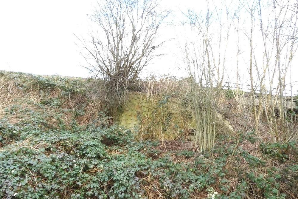
B44 was a rear line bunker between the Ostend-Brussels railway line and the Aalst-Ghent highway. It was very well hidden in the embankment of the second railway line parallel to the highway. It was located between B43 (620 m) and the now demolished B45 (210 m). The bunker had a rough stone appearance, originally it was painted in a light green background with red, ochre and emerald green spots on it.
A concrete edge was applied to the roof, a kind of large flower box, so that the soil remained on the roof of the bunker and the vegetation on the slope could smoothly transition to the roof of the bunker.
It had a long protruding wall in front of the loophole that was hidden behind a metal trapdoor.
The bunker consisted of a machine gun room and an access sash.
It was equipped as standard for a Maxim machine gun but also for the installation of a Hotchkiss or Colt machine gun.
B44 is completely overgrown, very well hidden in the slope of the railway line and is difficult to find. To reach it, you go past the Kwatrecht viaduct and past the Kalverhagestraat. A hundred meters further on you take on the Brusselsesteenweg the field road with another railway bridge a little further on. The bunker is immediately to the right behind this bridge.
Extensive information about this bunker belt can be found on the site Bunkergordel Bruggenhoofd Gent. There are also photos, sketches and technical data of the bunkers. A map shows the locations per municipality.
Do you have more information about this location? Inform us!
Source
- Text: TracesOfWar
- Photos: Marie-Christine Vinck


Nearby
Museum
Point of interest
- College Paters Jozefieten - Melle (Merelbeke-Melle)
- Institute Mariagaard Kwatrecht - Wetteren-Kwatrecht
- Halve Maanroute – information board 3, Battle of Gijzenzele - Gijzenzele
Monument
- Memorial Former Students College Melle - Melle (Merelbeke-Melle)
- Memorial 5th Line Regiment Kwatrecht - Wetteren
- Commemorative Plates War Victims Melle - Melle (Merelbeke-Melle)
Cemetery
- Belgian War Graves Wetteren-Kwatrecht - Wetteren-Kwatrecht
- Belgian Graves Veterans Gontrode - Gontrode (Merelbeke-Melle)
- Belgian War Grave Gontrode - Gontrode (Merelbeke-Melle)
Remembrance Stone
- Stumbling Stone Jacques Eggermontstraat 59 - Gent
- Stumbling Stone Hendrik Waelputstraat 11 - Gent
- Stumbling Stone Monterreystraat 63 - Gent
Fortification
Looking for reliable information or news facts about WW2? Do you want to create your own battlefield tour to sights of wars from the past? Or are you interested in war medals and their recipients? TracesOfWar.com tells you more!
More information

© STIWOT, 1999-2025. All rights reserved. Privacy statement, cookies, disclaimer and copyright